About Course
1.0. Introduction
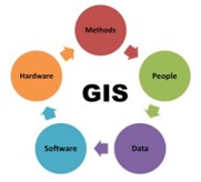
Geographic Information System (GIS) is one of the most remarkable innovations of all time, which has become an essential tool in resource management and planning. It is an information system comprising hardware, software, methods, data and people, all working together to capture, store, manage and manipulate, analyze, and display spatial information, to solve complex problems and enable decision making. It uses the concept of location of entities, whereby nearly everything can be assigned a geographic location. It uses basic concepts e.g. space, distance and direction.
1.1. Course Overview
This course will introduce you to the basics of GIS, with a focus of equipping you with fundamental skills of working with spatial data. It will introduce you to the nature, types and sources of spatial data and the use of various GIS Software to manage, analyze and visualize this data. The course includes both practical software training and explanations of the concepts you need to know to make informed decisions as you start your journey to becoming a GIS analyst.
1.2. Course Objectives
- Understand what GIS is and what it can be used for
- Get Started with various GIS Software
- Know how to create your own GIS data
- Understand the basics of Geospatial data management
- Case Study: Georeferencing and Digitizing and Creating a GIS Database for Nakuru City
1.3. Expected Learning Outcomes
At the end of this course, learners should;
- Understand what GIS is and its applications (Can you explain it to a fifth grader?)
- Have a basic understanding on the operation of ArcGIS and QGIS
- Be able to collect data from the field in real time, or from the internet and other sources
- Be able to import data into GIS software and perform basic analysis
1.4. Training Materials/Software
- A laptop/PC
- ArcGIS Desktop
- Quantum GIS
Course Content
1.0. Introduction to GIS Concepts
-
1.1. Definitions of core geospatial terminology and concepts
-
1.2. Objectives, components and applications of GIS
-
1.3. The history of GIS, how it is used today, and the future of GIS
-
1.4. Introduction to GIS Software – QGIS, ArcGIS Basics
2.0. Spatial Reference Systems
3.0. Nature of GIS Data
4.0. Geospatial Data Management
5.0. Geospatial Analysis
6.0. Case Study
Student Ratings & Reviews